
Osogoche trekking

Among the lagoons...
Difficulty: Average, 22 Km, from 2 to 3 days.
Elevation: From 3500 to 4200 meters
Maps: IGM 1:50 000: CT-Ñ IV-A4 Totoras.
Best time to visit: December till April for the driest months. Other months are variable with probability of fog and rain.
Special equipments: none
Water: For the first part of the trek, up to the collar foresee its water, after brooks of clear water abound.
Permits and fees: No official tax but the Indian of the communities can ask you for a contribution to cross their land.
Reserve: You must buy all the basic in Riobamba, in Atillo you will only find a small store for the neglect. It is also easy to buy good fresh trout and some cheese.
.JPG)
.JPG)
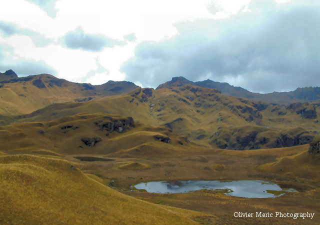
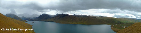
Trek: this trek allows you to approach some of the most beautiful height Ecuadorian lakes, far from the tourist roads in the middle of numerous authentic native communities. Numerous points of view on the trek road will allow you to admire the different lagoons, the Chimborazo and the volcano Sangay always active.
With a little bit of chance you will observe the majestic Condor flight.
There are more than sixty lagoons in the canton of Atillo and Osogoche. Numerous legends arise from the mystic atmosphere which gives the fog to these lakes.
Curious phenomena exist, «the birds suicide» which did not find scientific explanation, at the beginning of September thousands of small called birds Cubibigs flies over the lakes of Osogsche (lagoon Matayán and Cubillín). Then, many of those just "fall" literally in the lakes and die Most of the trek is through field, but there are numerous animals roads and the low vegetation of « paramó » facilitates the navigation.
.JPG)
.JPG)
Road: the trek begins ar Atillo Grande in the South of Atillo chico having crossed Río Atillo. The road continues behind a fish breeding where we can buy fresh trout. At the Cerro Baypungu (4120 m) feet, which extends southward, begins the ascent. The Northwest side is covered with a pine forest which we shall follow until our first objective: the crest over Río Cachi which continues to rise southward before taking the direction of the Southwest. We shall go up to the highest point to observe towards the Northwest the Atillo and Colay lagoon and the perfect Sangay volcano cone, in the East and in the Southeast of numerous lagoons, Iguan Cocha, Pucacocha, on the West the Río Bolsa Huaycu and towards the Northwest the Chimborazo Think of taking a panoramic By continuing southward, passing by the Sasquines summits, after one hour of walking we arrive at the small cliff base on a muddy ground with some perfect places to camp. Having crossed the small swamp we shall go to the pass between summits marked 4348m and 4377m on the IGM maps, called respectively Achipungu and Sasquines. 30 minutes are necessary to join the pass ( 4200m) where from you can see the Osogoche lagoons. After the pass there are more pleasant places to camp near a small brook. The road comes down friendly along a sheep path to the Southwest towards the Río Osogoche valley. When we shall be over the lagoon Magtayán, we can either come down to the Osogoche community towards the western South, or come down to the lagoon eastward. Once in Osogoche we shall take the return road to Riobamba.
.JPG)
.JPG)
.JPG)
.JPG)
 The
price includes....
The
price includes....
- Transport, guide, meal, all the necessary equipment for the campsite except sleeping bag, entrance fee to the Sangay national park.
The
price does not include....
- The alcoholic drinks, tips, personal equipments.
to
know....
- The organisation and your safety is ours priority, we reserve the right to be able to modify the trekking route according to the level and the possibilities of the group or for climatic reasons. Our Ecuadorian guides are licencied by the ministry of the tourism.
- It is recommended to have its own walking shoes, not supplied sleeping bag.

Copyright(c) 2003 Chimbo Niño. All
rights reserved.
[email protected]