
Ilinizas trekking

Between sky and land...
Difficulty: difficult for North Iliniza, very difficult for the South, 15 Km, from 2 to 3 days
Elevation: from 3900 to 5125 meters
Maps: IGM 1:50 000: CT-Ñ IV-E1 Sigchos.
Best time to visit: from May till September and from December till January for the dry months.
Special equipments: for the ascent of the South Iliniza glacier, the high mountain equipments is necessary. No special equipments for North Ilniza
Water: water in the refuge, but set there to rise there.
Permit and fees: count 10 $ for the refuge and 5 $ for the entry to the Ilinizas park.
Conveniences: the refuge has 20 around beds, on the very rustic but authentic conditions.
Reserve: purchase possible for Quito or Chaupi.
.JPG)
.JPG)
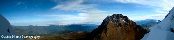
Trek: the name Iliniza became widespread to indicate both summits, but the natives call the highest Iliniza, situated in the South. Other one, in the North, is called Tioniza. These names are of Atacameño origin and mean respectively male peak and female peak. The Iliniza measures 5248 m and the Tioniza 5125 m, from the parking to the refuge you will have a magnificent sight on Corazón 4788 m, Atacazo 4463 m, Pichincha 4675 m and of the Pan-American East side on Cotopaxi 5897 m, Rumiñahui 4712 m, Sincholagua 4893 m and Pasochoa 4199 m. They are all magnificent active volcanoes, and you will approach bit by bit these two magnificent summits that are Iliniza and Tioniza.
Road: From the Pan-American road, we shall take the direction of Chaupi, on the right-hand side after the Machachi toll by coming from Quito. In the village it is advised to rent the services of a villager to rise up to the refuge parking which is situated in 3950 m. Count 3h00 (4h 00 if the weather is very nice) to rise up to the refuge, 764 m of elevation on 2 Km. A map on the parking indicates you the road which is well marked out until the arrival.
.JPG)
.JPG)
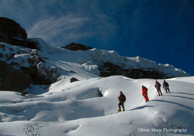
Take advantage of the end of the afternoon to rest. To arrive with the sun rise in the North summit, you have to get up at 4:00 am in the morning. The road goes westward up to a fork, we shall set then northward. No difficulty following the cairns which mark out the path up to the summit. A passage, called « La pasa de los muertos » is a little bit technical when it is snowed, the rest is depend on your physical condition seen that we pass from 4731 m to 5125 m in 1,5 Km. Of the summit we can see South Iliniza, Cotopaxi and its snow coat in the Southeast. To the Cotopaxi North side, is Rumiñahui and Pachoa, behind these two volcanoes you will perceive Antisana and Sincholagua. In the North, from the closer to the farther, stand the Corazón, the Atacazo and the Pichincha. To the West extends the Pacific Ocean. We shall take time to savor the recompense of all our efforts, this panorama is unique. South Iliniza is very technical and requires all the indispensable equipment for the glacier ascension with slopes which can go to 70º if you want to go up to the summit. To do it the guide will wakes us at 2:00 am in the morning, we will begin by rising up to the pass between both Ilinizas at 4900 m, then we get down again on the West face in 4700 m to take the glacier road which begins at 4820 m. From there begin the ascension on a hillside between 30 and 40º on 200 m elevation, then the hillside stiffened before of arrived at a "flat" where we will climb a ice wall. Less than 100 m separate us from the summit, think in save some energy for return, but once at the top, the words become useless
.JPG)
.JPG)
.JPG)
.JPG)
.JPG)
 The
price includes....
The
price includes....
- Transport, guide, meal, all the necessary equipment except sleeping bag, entrance fee to the Ilinizas national park.
The
price does not include....
- The alcoholic drinks, tips, personal equipments.
to
know....
.JPG)
- The organisation and your safety is ours priority, we reserve the right to be able to modify the trekking route according to the level and the possibilities of the group or for climatic reasons. Our Ecuadorian guides are licencied by the ministry of the tourism.
- It is recommended to have its own walking shoes, not supplied sleeping bag.

Copyright(c) 2003 Chimbo Niño. All
rights reserved.
[email protected]